News and Opinion - From Washington Island, Wisconsin - The Surrounding Islands and the Island Community - From a Ferry Operator's Point of View
Saturday, November 10, 2012
VETERANS DAY
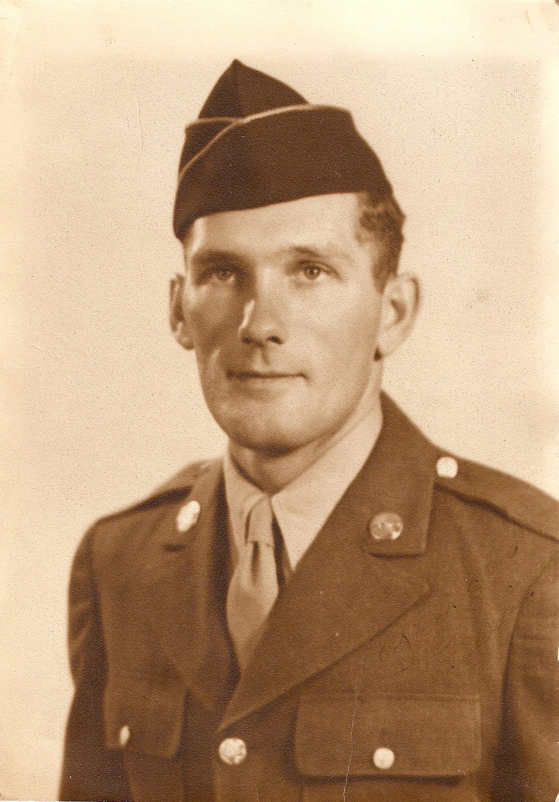
For the past several weeks I've been collecting photos of Island veterans. Some of those photos had been in the upstairs of the Legion Hall for years, but most were recently dug from photo albums or taken down from wall frames for image scanning.
Chuck and Jewell Lee Grandy have collaborated with me on this project. They've contacted many veterans or their families, and they've also sifted through the Island Archives, searching for photos of men and women in uniform. I think we now have well over 100 individuals represented.
As it happens, many photos were lost or misplaced and can't be found, or there were none taken of an individual to begin with. If possible, we want photos showing the veteran in their military uniform, posed in dress uniform, or in their work uniform, or both. They provide an interesting contrast, the young soldier or sailor compared to the image of someone we're currently familiar with now, who may be in their 60s, 70s or 80s.
Despite our best efforts (and an admittedly late start without public announcement), this Power Point project-in-the-works, despite being incomplete, will be shown on screen during this year's Veterans Day program: Monday morning, 10:30 a.m., at the Trueblood Performing Arts Center. Because the photos to be seen will represent only a fraction of the many veterans with a Washington Island connection, this project will continue.
As more photos come in - either emailed in digital format or as physical photos that we can scan - we'll add to this file. Eventually, this file of photos, accompanied by names, branch of service and perhaps key enlistment dates, will be donated to the Island Archives. Family members and researchers in future generations might find those photos to be a useful connection with their island past.
John Gay, who is a veteran and an Island summer resident, has conducted numerous interviews with island veterans during these past several years. John volunteered to participate in a Library of Congress project designed to capture the stories of as many veterans as possible. John records his interview with each veteran using a prescribed template of questions, and then the audio record is transcribed by others. As you can imagine, each interview takes time, including scheduling an appointment with a willing veteran. Later, there is a follow-up to review the transcribed interview for accuracy. These photo images recently obtained in our project will add to John's efforts, because for many veterans', especially those persons no longer living, photos might well be the only information available about their military service. (One completed binder will go to the Library of Congress, and a second binder will go to the Island Archives.)
During the course of this photo project, I had the chance to visit with a number of veterans, and in one meeting in the Ferry Office a week ago I was introduced to Mike Kumnick of Colorado. Mike is a Viet Nam veteran whose parents, Fred and Lou Kumnick retired to Washington Island in the 1980s. Fred was an active American Legion member and for a time served as Post Commander. Although Mike and I might have met briefly, years ago, it was through this blog that Mike kept in touch with the Island.
Published here is a photo of Mike's father, Fred Kumnick, U. S. Army, WWII.
In order to make our file more complete, please consider allowing Chuck Grandy, or myself at the Ferry Line office, to scan your military photo, or one of an Island veteran in your family. The scanning process takes about five minutes, and you keep the original.
- Dick Purinton
Note: About one week ago I had difficulty with my password to access this blog site, and with no clue to overcome this, I waited for help. Coincidentally, in an unrelated error of movement my irresponsible forefinger, I eliminated my entire photo file in one "Poof." My hope for help rested in Chris Haertig, who with his expecting wife Megan, had left for Sturgeon Bay in anticipation of their second child. They have since become parents to Gideon Joseph. When Chris returned, he restored my photos from the trash and fixed my password problem, which put me happily back in business.
Friday, November 9, 2012
| Island CTA representatives off on a lark last Wednesday: Jim Rose, Christy Davidson, Bill Nauta, Dick Purinton, Mary Andersen, (in front) Carol Stayton and Ann Rose. |
The sun was trying hard to shine Wednesday morning when the above photo was taken in front of the Visitor Center. By noon clouds had filled in and rain began to fall. We've seen lots of clouds and rain recently, with much cooler temperatures. Still, we're happy to receive the moisture, and it comes without hurricane-force winds experienced in the northeast.
The purpose of Wednesday's adventures was to familiarize ourselves with businesses and attractions in Door County, to be better Tourism Ambassadors by absorbing "ongoing education." This also leads into the annual CTA re-certification. The CTA moniker means "Certified Tourism Ambassador." When a visitor center at Norhtport was developed two years, the Ferry Line and the Island Chamber of Commerce decided training might be a good thing, through instilling a consistent and professional manner in which we can apply our knowledge of Door County when serving visitors. Members of the group shown above work in the Northport Visitor Center, but two are also Ferry Line ticket sales people. Each of them makes thousands of contacts with visitors in a few months' time. (There were also several others who were unable to make the trip with us.)
The Tourism Ambassador program, a national program, was brought to Door County by the Door County Visitor Bureau. Short, four-hour classes are designed to give workers in the local tourism industry a framework for behavior and attitude when serving customers. An important benefit, in my opinion, comes from the added emphasis on being well-versed, not only in Washington Island information, but for other parts of Door County. And if the many other Door County CTAs are equally well-rounded, they will be knowledgeable in northern Door and Washington Island information, too. This concept recognizes the need to be supportive of the Door County Tourism as a whole, large and small businesses and attractions.
| Bob Purman gave a short course in the production of hard cider at his Ellison Bay facility. |
Stop #2 was Evergreen School, and we were hosted by its imaginative and creative owner, Karin Overbeck. The visual experience is so unexpected for the first-time visitor that it is impossible to properly describe it here in one, short paragraph.
Our third major stop was the Door County Historical Museum, a gem of a museum right under our nose, so-to-speak.
How many times have we driven past the limestone building on the corner of 4th and Michigan in Sturgeon Bay without noticing it, on our way to the post office, Younkers or the bank?
Its a terrific place to spend an hour or two (closed now for the season except for one special Christmas date in December) with no entry fees. This facility and is funded by the taxpayers of Door County and through donations, so we ought to take advantage of it more often. My last Door county Museum visit, I admit, was in 1979 when I borrowed the wooden ship's wheel from the original steam ferry Robert Noble. That was when Otis Trodahl was museum curator and before a major museum remodeling took place! They are ready for another expansion today, Maggie Weir and Ann Jinkins, informed us, with more visitors and a few large donors being the major roadblocks.
- Dick Purinton
Tuesday, October 23, 2012
DETROIT HARBOR IDEAS ADVANCED
Detroit Harbor, Washington Island -
A meeting between Coast Guard and harbor users took place during the early afternoon today.
Current buoy types and locations, limitations on buoy placement due to depth and available equipment, changes to the buoy numbering system, possible change to the entrance light lens color, and one new and different buoy location were among the items freely discussed.
One new idea proposed by the Coast Guard was renumbering in order to conform with typical, progressively numbered designations (right now several buoys have the designation "Alpha" as part of their description, usually meant as a temporary marker). A significant proposed change would remove buoy 2A from its present location opposite the tripod, with a new nun located further south, near the start of the deep channel. That relocation would permit the Mobile Bay and its buoy barge to install and maintain a larger sinker and a year-around, ice class buoy. If this idea proves doable, it might lead to further refinement with a lighted buoy next season. This new buoy would then be numbered "2," and the buoy designations of the others would be changed accordingly, ascending into the harbor in numerical order, the tripod becoming #3.
A question was posed about changing the color of the tripod light to green from present white, and this brought comments both for and against.
But, while general consensus on many of the issues may have been reached at the table, for the present the ideas discussed remain only ideas until broader input is obtained, including a response from the command of the cutter Mobile Bay.
Slight position adjustments for the foam buoys beyond the ferry dock received input from the Shipyard's Lou Munao, whose experience reflected what seems most intuitive and useful for recreational boaters.
All ideas advanced today, of course, will be published in Notice to Mariners when they are officially adopted, and presumably they will also be open to public comment. Meanwhile, the Detroit Harbor waterway survey is still ongoing, and anyone (but especially users of the waterway) can comment on these matters. My personal impressions were that the Coast Guard representatives we met with today were not only completely open to suggestion, but they also proposed several excellent ideas that had not previously been posed. Quite informal, this meeting was characterized as one of mutual respect, with interest in making the harbor safe and accessible for users.
Representing the U. S. Coast Guard were: two representatives, Two Rivers Aids to Navigation (responsible for foam buoys); BM1 Ryan Beddes, Sturgeon Bay Coast Guard Station and Supervisor, Station Washington Island; Doug Sharp, Marine Information Specialist, Aids to Navigation (Ninth District, Cleveland); and Chief Warrant Officer Jon Grob, ATON Officer (Sector Lake Michigan, Waterways Management).
Local input came from five licensed Washington Island Ferry Line operators, and from three representatives of the Shipyard Island Marina whose customers have experienced difficulty negotiating the buoy system while enroute to the marina location.
- Dick Purinton
A meeting between Coast Guard and harbor users took place during the early afternoon today.
Current buoy types and locations, limitations on buoy placement due to depth and available equipment, changes to the buoy numbering system, possible change to the entrance light lens color, and one new and different buoy location were among the items freely discussed.
One new idea proposed by the Coast Guard was renumbering in order to conform with typical, progressively numbered designations (right now several buoys have the designation "Alpha" as part of their description, usually meant as a temporary marker). A significant proposed change would remove buoy 2A from its present location opposite the tripod, with a new nun located further south, near the start of the deep channel. That relocation would permit the Mobile Bay and its buoy barge to install and maintain a larger sinker and a year-around, ice class buoy. If this idea proves doable, it might lead to further refinement with a lighted buoy next season. This new buoy would then be numbered "2," and the buoy designations of the others would be changed accordingly, ascending into the harbor in numerical order, the tripod becoming #3.
A question was posed about changing the color of the tripod light to green from present white, and this brought comments both for and against.
But, while general consensus on many of the issues may have been reached at the table, for the present the ideas discussed remain only ideas until broader input is obtained, including a response from the command of the cutter Mobile Bay.
Slight position adjustments for the foam buoys beyond the ferry dock received input from the Shipyard's Lou Munao, whose experience reflected what seems most intuitive and useful for recreational boaters.
All ideas advanced today, of course, will be published in Notice to Mariners when they are officially adopted, and presumably they will also be open to public comment. Meanwhile, the Detroit Harbor waterway survey is still ongoing, and anyone (but especially users of the waterway) can comment on these matters. My personal impressions were that the Coast Guard representatives we met with today were not only completely open to suggestion, but they also proposed several excellent ideas that had not previously been posed. Quite informal, this meeting was characterized as one of mutual respect, with interest in making the harbor safe and accessible for users.
Representing the U. S. Coast Guard were: two representatives, Two Rivers Aids to Navigation (responsible for foam buoys); BM1 Ryan Beddes, Sturgeon Bay Coast Guard Station and Supervisor, Station Washington Island; Doug Sharp, Marine Information Specialist, Aids to Navigation (Ninth District, Cleveland); and Chief Warrant Officer Jon Grob, ATON Officer (Sector Lake Michigan, Waterways Management).
Local input came from five licensed Washington Island Ferry Line operators, and from three representatives of the Shipyard Island Marina whose customers have experienced difficulty negotiating the buoy system while enroute to the marina location.
- Dick Purinton
Saturday, October 20, 2012
THIS and THAT
| Friday, October 19th. |
It's been a rainy, gray week on the island, with temperatures consistently in the 40s, or low 50s at best. But we're about to turn a corner, it appears, with sunshine and warmer days ahead. Mixed with more rain, which in the scheme of things isn't all bad. There are but two days, today and tomorrow, left with Cherry Train tours for this season. Terri Moore has done her best to keep her passengers interested and warm, despite the dampness, and it goes to show what business might have been if skies had been sunny. Our beautiful fall colors melted with the rain sometime in the past days, and now half of that color lies on the ground after pummeling winds.
One qualification to the last blog: I showed two photos of Kap's Marina's north section, which is currently very shallow. What I failed to explain is that the entire south portion of the marina, toward the U. S. Coast Guard station, has adequate depth throughout, including the entrance, for all types of craft. Thanks to extensive dredging last winter in preparation for the new Coast Guard vessel, including approaches to the fuel supply, no boater will have a problem in that part of the marina.
Island Outpost receives commendation: Our Wisconsin Assemblyman, Rep. Garey Bies, was on the island Friday morning to visit and also to present an Assembly proclamation to Jim and Debbe Anderson of the Island Outpost, in recognition for their successful 40 years in business. A brief history of the Island Outpost appeared in the Island Observer in late summer, which recounted the use of the property by several owners for fishing, and freighting, before a shop was first opened in one portion of an old net shed by Cal Davidson. One year later, with military service recently behind him, Jim opened up the Island Outpost, and it has been a landmark of Lobdell Point ever since.
Rep. Bies, a U. S. Navy veteran, will be guest speaker for the annual Veteran's Day Program at the TPAC, Monday November 12th at 10:30 a.m.
| From left: Rep. Garey Bies, Jim and Debbe Anderson |
What the heck? and other, similar, thoughts have run through the minds of people I've encountered since my nose surgery at the dermatologist's Thursday. The Moh's procedure was performed, in which a thin slice of tissue is removed, then examined in the lab to determine if cells are cancerous. After the second round, I asked the doc, "How big is it?" and he replied, "Smaller than a dime." After the fourth, and final round, I asked again, "How's it looking?" and he said, with humor (I think), "It looks like someone stood on your nose and took a swing with a golf club." Well, given the divot removed, it took a skin graft to fill, and with that, additional bandaging to secure the whole shebang in place, which I now wear for one week before removal. Encounters since then have produced many humorous and expected remarks, like: "Halloween's just around the corner", and "I'd like to see what the other guy looked like." Personally, I think back to the Polanski movie, Chinatown, in which investigator Jack Nicholson gets his nostril sliced by a sharp knife from a tough guy, then wakes up in bed later and the camera angle shows the stitches up close, pointing toward the ceiling. It was a classic, and I hope this nose will also return to classic form in a few week's time.
In the meantime, I had the pleasure one day later to parade my new, ridiculous face in front of a kind and attentive audience at the Clearing. I had been invited by Norb Blei to speak for a bit on Rock Island and my current writing/history project on Thordarson. Norbert's class had spent the previous week on various authors and sources that represented Rural Writing, and that was the point of my appearance. (Julian Hagen visited the previous afternoon and spoke about his local, island inspiration for song lyrics.) Anyhow, it was a pleasure to have been asked, and after the initial introduction, all eyes were on my nose - or so I thought. Actually, it went very well, and afterward at least three people mentioned they had undergone similar treatment in the recent past, and all had emerged on the other end in good health and restored appearance. My appreciation once again, for Norb Blei to think of me, and to extend that opportunity which caused me to organize my viewpoint on where I stand with the Thordarson project (maybe 2/3 of the way, at this point.) - Dick Purinton
| Better days ahead! |
Sunday, October 14, 2012
LAKE LEVELS
| Scene at Kap's Marina Friday, Oct. 12. |
The Army Corps of Engineers report from the internet (which they update weekly due to general interest) shows that we are "zero" difference from the all-time recorded low water of 1964. In other words, we're at the bottom of the recorded lake level curve, a statistic that took almost another fifty years to reach once again.
I stated in yesterday's blog that we had dropped approximately 8 inches in the several weeks I was away, and I believe that to be true, although it was based on casual observation rather than accurate readings from known benchmarks. According to Hoyt, who used a line painted on sheet piling, the loss since September 1 has been 16 inches. During northerly winds, which we have had of late, the levels drop more noticeably, what might be referred to as a "basin effect," where pressure of wind forces water from bays and shallows in the direction of the wind's flow (lower Michigan).
This fluctuation is serious for us, but it is all relative, of course. If we lived where there were daily tidal movements of several feet, we would be equipped to deal with such phenomena, or would locate essential water services where there was less chance of being adversely influenced by the tides. (Floating stages for loading are common on rivers and coasts, especially for boarding passengers; more elaborate, longer sections of ramps are used for boarding vehicles.)
At the dinner table on our trip we visited with a man from a large inland lake in Texas, an area hit hard by drought of the last year, where cattle have been shipped to northern feedlots due to lack of hay, and where his lakefront has seen an 80-foot drop. He laughed when we said we had experienced a drop of several feet in recent years, and that the historic fluctuation between high and low was in the range of six feet of lake level.
Hard to get sympathy and understanding with those figures, and we didn't even try.
| Access to the marina's slips and launching ramp may be for canoes only, given reduced depths. |
And, there is the matter of our getting used to a routine, one that was based on stable lake levels, where use of harbors and other natural shoreline features led to the development of both shoreline and upland properties. There is no law that says today's level couldn't be the new normal lake level, but we happen to have faith that precipitation will sooner or later cause a net gain in lake storage over the next few years as has happened in the past.
The immediate future, though, will cause us to examine how we operate ferries, and what contingencies we will adopt during the interim.
- Dick Purinton
Saturday, October 13, 2012
A GOOD DAY FOR ??
| This was taken during a "lull" in the morning's rain. |
Washington Island, Wisconsin -
What can you do on a day that is only 40 degrees, raining, with a windspeed approaching 25mph from the south?
Find an activity indoors, enjoy the warmth of a wood fire, and wait for the water levels to stabilize are my personal recommendations. Yesterday was a day of brilliant, blue sky which made the autumn leaves standout. The island is about 50-75% in full color, with only a small percentage of leaves on the ground. This may change after today's wind and rain, but the colors are later, and the leaves on the trees longer, than most years.
The water level continued to drop during the time I was away for two weeks. During that time, the lake level dropped another 8 inches or so. We're contemplating modifications not only for the approaching winter, but also for the coming year, that will enable us to load vehicles - especially low or heavy trucks - with the low water extremes. Dredging in certain areas will also be a part of that plan, which will require a state permit and lead-time to get into motion, not to mention planning for project costs.
The ferry Robert Noble which has the lowest deck height in relation to the water, is now sidelined and is likely moored for the remainder of the season. Additional concerns are with the ferry Arni J. Richter with its draft requirements (nearly two feet greater than that of the other ferries when loaded). Rich Ellefson and Con McDonald began preparations at the Potato Dock, just in case, lowering tires used as fenders, improving to the dock surface, and welding braces. There is also a need for dredging to ensure maneuvering in the dock area. Continued drops in water levels could make the Potato Dock an option, and yet a lack of good all-around facilities at the Potato Dock would mean that small trucks and autos could be off-loaded, but that long semi-trucks might not be accommodated, should it be the only landing available.
Channel depth will also be a concern in the late months of the year, when breaking seas can cause the ferries to dip in a trough when entering port. This could easily mean the difference between running or not, in order to avoid the possibility of touching bottom in a surfing condition. Prudent judgement in daily operation will need to be exercised to prevent occurrence of such an incident.
A good news item is that the steel ice hull buoys #2 and #6 were reset in the harbor by the Muskegon Coast Guard crew. They came, reset, and headed back across the lake while the weather was good. An October 23rd "pow-wow" on the island with Coast Guard representatives regarding Detroit Harbor aids to navigation has been scheduled, we have been told.
| Outstanding maple on the post office corner, taken Friday Oct. 12. |
Friday, October 12, was bright and beautiful (though still in the 40s for temperatures). The Selvick towing company towed a McMullen & Pitz work barge to the U. S Coast Guard facility here to begin work Monday on a new pier for the Coast Guard's recently acquired 45-foot patrol vessel. Of course, the local station is now closed for the season, but this dock work, contracted to the Manitowoc marine construction company, is intended to be ready for the coming season.
| The Selvick tug towed the work barge as close as depth allowed, then headed back to Sturgeon Bay. A small boat then pushed the barge into position. |
Today, while hundreds of visitors mill about in Sister Bay during their annual Fall Festival looking for places to get out of the wind and rain and keep warm, we're seeing a small fraction of the traffic we'd typically serve who are bringing their autos to the island. Today's forecast was for 100% chance of rain (and they were right), and for tomorrow it will be a 90% chance of rain. Coupled with the rainy business bust of last weekend when it also rained, October's tourism numbers will be well off the anticipated tally.
The good news is that it is raining hard, and if this trend should continue we may have some of our lake water back.
- Dick Purinton
Sunday, September 23, 2012
HOBBYIST BILL
Washington Island -
Bill Crance has the knowledge, and maybe just as important, the right temperament, to restore vehicles. This project is his second since retirement two years ago.
He purchased his Model-A in pieces that were partly restored but still were a long way from completed assembly, a project began by the late Henry Nelson. Using his knowledge and intuition for things mechanical, and by listening and learning from others, and by doing as he went along, gradually, and with characteristic patience, Bill restored his car. He took the motor to a county machinist who specialized in reworking motors. He and his nephew "Elvis" repaired rusted fenders and floors, then painted the parts, and, finally, he reassembled the pieces.
Son Thor and I had a chance to visit Bill and his car in his shop last December 2011. That was a stage when the car looked quite complete from the exterior, and when Bill was partway through installation of an interior liner. The seats had yet to be installed. There were a few things, here and there, he pointed out to us, all of which he finished over the next several months. The car's paint job looked professional - and it was. Bill's son-in-law is an expert who operates a custom car refinishing business in the Chicago area.
By early June Bill, had his car out on island roads, trying it out the ride, and he stopped on one such jaunt at the Ferry Line office and offered me a ride. He and neighbor Bob Nikolai, also an avid Model-A restorer and collector, planned a road trip later that month to a national Model-A meet in Marquette, Michigan. This would be a fair trek in two old vehicles, but they left the island confident they'd thought of everything - or could fix and repair along the way as necessary.
The only glitch in their travels came on the return leg, when Bob's exhaust manifold loosened and fell off, on Green Bay's east side (near Highway 41 Tower Drive bridge). Bill, following in his car, retrieved it from the roadside. They wired it back into place for the home stretch through Door County.
Here are more photos of Bill's project, both in his shop and on the road. - Dick Purinton
Bill Crance has the knowledge, and maybe just as important, the right temperament, to restore vehicles. This project is his second since retirement two years ago.
He purchased his Model-A in pieces that were partly restored but still were a long way from completed assembly, a project began by the late Henry Nelson. Using his knowledge and intuition for things mechanical, and by listening and learning from others, and by doing as he went along, gradually, and with characteristic patience, Bill restored his car. He took the motor to a county machinist who specialized in reworking motors. He and his nephew "Elvis" repaired rusted fenders and floors, then painted the parts, and, finally, he reassembled the pieces.
Son Thor and I had a chance to visit Bill and his car in his shop last December 2011. That was a stage when the car looked quite complete from the exterior, and when Bill was partway through installation of an interior liner. The seats had yet to be installed. There were a few things, here and there, he pointed out to us, all of which he finished over the next several months. The car's paint job looked professional - and it was. Bill's son-in-law is an expert who operates a custom car refinishing business in the Chicago area.
By early June Bill, had his car out on island roads, trying it out the ride, and he stopped on one such jaunt at the Ferry Line office and offered me a ride. He and neighbor Bob Nikolai, also an avid Model-A restorer and collector, planned a road trip later that month to a national Model-A meet in Marquette, Michigan. This would be a fair trek in two old vehicles, but they left the island confident they'd thought of everything - or could fix and repair along the way as necessary.
The only glitch in their travels came on the return leg, when Bob's exhaust manifold loosened and fell off, on Green Bay's east side (near Highway 41 Tower Drive bridge). Bill, following in his car, retrieved it from the roadside. They wired it back into place for the home stretch through Door County.
Here are more photos of Bill's project, both in his shop and on the road. - Dick Purinton
Thursday, September 6, 2012
BUOYS RECONSIDERED!
| A response from the U. S. Coast Guard Ninth District stated that buoys #2 and #6 would be reset shortly. |
Word was received this morning that the U. S. Coast Guard Ninth District Waterways Management has reconsidered placement of #2 and #6, and will be conducting further study of Detroit Harbor aids. The email exhange follows:
From: richard@wisferry.com [mailto:richard@wisferry.com]
Sent: Thursday, September 06, 2012 1:34 PM
To: Kugel, Ralph BOSN2
Cc: Hoyt Purinton; Rich Ellefson; Joel Gunnlaugsson
Subject: Re: Confrence call
Mr. Kugel - I would like to add my thanks to your email response, for reconsidering the placement of Buoys 6 and 2 that we believe are of immense help to our ferry captains, and for your continued study and solicitation of comments regarding the Detroit Harbor waterway.
We understand that your organization's job, collectively, is to manage all of the Ninth District aids to navigation, no small task, and that as such it may involve more than we in our corner of Lake Michigan may appreciate. If anything, this tells us we ought to make a more concerted effort to communicate with your office (and the other way around, too). Again, our appreciation for your willingness to listen and solicit comment.
- Respectfully, Richard Purinton, CEO, Washington Island Ferry Line, Inc.
On Sep 6, 2012, at 9:51 AM, Kugel, Ralph BOSN2 wrote:
Hoyt,
Thank you for all your input. We are going to step back and conduct a waterway study of Detroit Harbor. The study is currently being advertised in the Great lakes Notice to Mariner. Comments can be made to Coast Guard Sector Lake Michigan in Milwaukee or myself. Your comments are very valuable in this study as they have been all along and we will continue to take comments until 01 January 2013. We want to make sure that we get it right for all users. I have attached a survey that you could reproduce locally and hand out to marina patrons, ferry captains, other waterway users if you like. Mr. Doug Sharps contact information is located at the bottom of the survey.
We are sending ANT Muskegon back out to put 2 and 6 back in the water. They should be there next week weather depending.
Again, thank you for all your valuable input and local perspective.
Ralph
***** (With thanks to all who have commented with their support and advice... Following - printed BELOW - is a form supplied by Mr. Kugel that can be used by boaters and citizens to express their thoughts about aids to navigation in Detroit Harbor. DP) ***
Waterway Analysis and
Management System Survey
Name of
Waterway:_________________________________________
User Information
___Commercial User
___Recreational User
Name:________________________________________________________
Address:________________________________________________________________________________________________________________________________________________________________________________
Phone:________________________________________________________
E-mail address:
________________________________________________
Company/Employer:____________________________________________
Number of years in the
maritime industry or number of years using this waterway:____________________________________________________
Number of transits in the waterway
per year:________________________
Number of night transits of waterway:_____________________________
Seasonal Dates:
Start:______________End:____________________
Name of
Vessel:________________________________________________
Vessel Description:_____________________________________________
Length:___________Beam:__________Draft:_________Gross
Tons:_____
Net Tons:_________Bridge
Height of Eye:___________________________
Cargo
Carried:_________________________________________________
Navigational tools used:
(ECDIS/ECPINS, GPS, DGPS,VISUAL,
RADAR)_____________________________________________________________________________________________________________________________________________________________________________________________________________________________________________
What area do you believe is
the most dangerous or difficult to navigate:_____________________________________________________________________________________________________________________________________________________________________________________________________________________________________________
Are
the floating aids to navigation (lighted and unlighted buoys) adequate for this
waterway:_______________________________________________
_______________________________________________________________________________________________________________________________________________________________________________________
Are
the fixed aids to navigation (lights, ranges, lighthouses, daybeacons) adequate
for this waterway:_______________________________________
_______________________________________________________________________________________________________________________________________________________________________________________
Are
the year round and lighted ice buoys adequate:____________________
_______________________________________________________________________________________________________________________________________________________________________________________
Are
there buoys that you feel should be changed to fixed aids to
navigation:___________________________________________________________________________________________________________________________________________________________________________________________________________________________________________
Are there any buoys that
could be eliminated from this waterway:________
_______________________________________________________________________________________________________________________________________________________________________________________
Are
there any buoys with sound signals that the bell or gong could be
removed:______________________________________________________
__________________________________________________________________________________________________________________________
__________________________________________________________________________________________________________________________
Are
there any areas that require additional aids to navigation in this
waterway:_______________________________________________________________________________________________________________________________________________________________________________
Do
the nautical charts, Coast Pilot, and Light List meet your needs for this
waterway:____________________________________________________________________________________________________________________________________________________________________________________________________________________________________________
Are
there private Aids to Navigation that you find misleading or interfere with the
current system in the waterway:_____________________________
_______________________________________________________________________________________________________________________________________________________________________________________
Any
addition comments on this waterway:___________________________
________________________________________________________________________________________________________________________________________________________________________________________________________________________________________________________________________________________________________________________________________________________________________________________________________________________________________________________________________________________________________
________________________________________________________________________________________________________________________________________________________________________________________________________________________________________________________________________________________________________________________________________________________________________________________________________________________________________________________________________________________________________
Thank
you for taking time to comment on this waterway. Your input as a mariner very valuable to the U. S. Coast
Guard in evaluating waterways to make them safe and as easily navigable as
possible. Please fell free to
contact Mr. Doug Sharp at william.d.sharp@uscg.mil
or (216) 902-6070 with any other questions or concerns about any aids to
navigation in the Great Lakes.
Wednesday, September 5, 2012
LATE LABOR DAY RAIN
| Rain clouds brought welcomed moisture to northern Door County late Labor Day Monday afternoon. |
Detroit Harbor, Washington Island -
There's something about watching a thunderstorm develop in the west, the energy of white clouds lifting and rolling at the lip, dead silence for a short time before the wind shifts from the direction of the storm, then peals of thunder and torrential rain.
Its a powerful experience, one we haven't witnessed for awhile, and it came at the end of the afternoon of Labor Day. Ferries had already delivered weekend visitors to the mainland, those returning to their homes to begin work or school the following morning, and except for golfers in the Monday men's league at Deer Run who may have scattered indoors, this storm and the moisture it delivered came with perfect timing. The weekend - the whole preceding week, for that matter - had excellent weather, sunny skies, temperatures that ranged in the 70s. We could smugly say how happy we were to be living here. Then the weekend, too, was ultra-fine, the type of weather any visitor can appreciate, for any sort of activity, with a full moon - a blue moon - that beamed upon the waters of the harbors, fields and pastures.
According to several people with home rain gauges, precipitation ranged between 2-3". John Delwiche, official Island Weather Observer for NOAA who lives near East Side Road, measured just under 2" as an official Washington Island entry. But, John acknowledged that a mile this way or that could have easily made the difference of half an inch or more, so concentrated were the downpours.
(John's synopsis for August indicates that total Island August precipitation was 29% of the past 30-year average, and it was the 4th driest August since 1945!)
Will this rain help lake levels? Certainly, though it was quite concentrated in the northern lake region, will make some difference, but just how much is hard to say. There is a lot of lake to fill, not to mention swamps, ponds, creeks, the water table underground, and so forth. A wet fall from here on can only serve to benefit the overall level, however.
Monday, in what we observed as a good trend, the lake level increased a few inches, enough to sneak out for a sail without getting stuck. We hope that level holds for awhile.
- Dick Purinton
Tuesday, September 4, 2012
BACK WHEN MEN WERE MEN!
| Early chart of Detroit Harbor, from 1928 Light List, courtesy of Eric Bonow. At that time, wooden ferries crossed the harbor to land at the shipyard. |
Washington Island, Wisconsin -
We've been awaiting word from the U. S. Coast Guard Aids to Navigation representatives in Cleveland regarding our request for them to reconsider their policy for the intended, permanent removal of several steel floating aids to navigation in Detroit Harbor.
Late this summer we learned that all of the steel "ice hull" buoys would be pulled and then replaced with lighter, floating aids on a seasonal basis. This action would mean no floating aids to rely on for approximately five months of the year, including winter, and full reliance would necessarily shift to the two newly constructed cylinders and the long-established "tripod" entrance marker.
We had the opportunity to discuss our point of view in a phone conference with three Coast Guard officers who represented Ninth District Aids to Navigation, Cleveland, two weeks ago. We're hoping the intervening period of time brought about a change of policy regarding those buoys, aids that we consider critical for year around, daily ferry operations.
Boiled down, we requested that buoys #2 and #6 be reset for year around use. Such steel buoys are superior radar targets in fog or snowstorms over the smaller foam buoys, we said, and they always provide important visual reference for our ferry captains. We offered to assist with buoy setting using one of our ferries, if that were helpful, but we learned that there is a policy to not rely on such civilian help, or mix private aids with approved federal aids.
Of concern to us was that we had to repeatedly make our case, in several different ways, to be clear that those buoys are not just a nicety but critical to repeated, safe transit of the channel in varied conditions. Those new, large cylinders will provide strong visual and radar targets, we agreed, but there is nearly a 1/3 mile gap between entrance mark and the first cylinder, a time when an operator, attentive to his compass course, depth, GPS, radar and throttles, must use all of his senses at once to maintain safe course. Those floating buoys provided excellent visual reference when nothing else was available. This was certainly true for #2 buoy, but equally important for #6 that marks the reef opposite the ferry dock. Our ferries need to avoid this rock pile (now only several feet beneath the surface) each time the captain squares away on an outbound course. High winds, occasional current, and ice in the channel can add difficulty to what is essentially a visual piloting exercise.
We got the impression though our prolonged discussion that we needed to toughen up and get used to relying on the Colusus of Rhodes columns that stand tall over our harbor. We regret having sounded argumentative during the 75-minute phone conference, but when it turned into a debate on what the purpose of a buoy is, and how we ought to be able to safely navigate the channel without floating aids, was there a better way we could have gotten our points across?
The two buoys (#6 and #2) that we described as essential for our safe operations are already here on the island with their sinkers. The vessel that services them from Muskegon, and the sailors who man that vessel, are available and have already been funded. That leaves the cost of fuel and the orders to sail a 46-foot vessel across the lake every two years for buoy maintenance as the sole "obstacle," apparently. That vessel has limitations placed on its scope of service that make such a voyage in open water a violation of its intended use in protected waters.
It may indeed be time to toughen up.
Back in the days of sail and small mechanized freight boats, called hookers, there were but a few channel aids to assist them. That channel was natural, like a river, and not mechanically dredged.
Eric Bonow, as he has done many other times, sent along information in the form of a chart of the Detroit Harbor entrance from the 1928 Light List. It may be one of the earliest that depicts buoys marking the West Channel. At the outer end is the gas buoy with bell which then marked the south end of the shallow reef (rather than sitting on top of the north end as does the present day entrance buoy.) A bit farther in was a black can where the channel took a slight dipsy-doodle.
Another aid, called the "elbow light" on the old chart where the channel crooked off to the east, marked what Nathan Gunnlaugsson called the "false channel." A crib of stones marked this naturally deep route, and the mark's remains, a rock pile with a single, upright timber protruding from it, still shows itself to this day east of the dredged channel. To the west of that crib and the false channel is a two-foot shoal, presently marked by the #6 red nun foam buoy.
From my perspective, the channel then was minimally marked, and it must have been a tense time when vessel masters entered or left port. Maybe they produced greater testosterone than we do today.
The frequency of modern day ferry travel to and from Detroit Harbor, and the consequences for striking bottom (which includes reporting such incidents to the Coast Guard, and the possibility of haul-out for repairs) won't be satisfied by an old-fashioned spit of plug juice over the side or the vow to do it better the next time.
If we read our regulators' remarks correctly, now is the time for us to toughen up, sharpen our boat handling skills, and be thankful for all we've been given from our federal government!
We hope to bring good news to our readers when such news is available. - Dick Purinton
A few additional thoughts...
Several comments have already been received by direct communication regarding the above essay, and one of them was a comment on the Coast Guard's preference for the installation of "gated" buoys whenever possible. And while in general this practice may be a proven benefit to navigation, providing a guide for both sides of the waterway, in the case of Detroit Harbor there were only the red floating buoys, for decades, in addition to the green entrance buoy. (And also the exception of #9 placed at the north end of the channel in the turning basin, now replaced with a white and red striped buoy). Later, about the year 2001- which happened to coincide with a completed, major dredging project in front of our island ferry terminal - green can #5 was installed. It proved beneficial as a turning mark for our ferries, marking the shallows along the west side of the channel much in the same manner #6 now marks the hump on the east side of the channel. But, cost and engineering overkill aside, that new cylinder #5 does not appreciably aid navigation because even though such a "gate" of cylinders may look good on paper, it becomes an immovable obstacle both for vessels and for ice. And when you're coming into the harbor in low visibility, by the time you're near #5 you've already got a visual bead on the end of the ferry pier. We're hoping winter ice will not be held back by that cylinder.
The other comment had to do with the new, foam buoy #6A placed approximately one month ago at the north end of the "hump," opposite the ferry landing. This buoy #6A was installed as a response to several groundings by sailboats as they cut #6 too close to starboard and headed directly for #8 buoy over the top of the hump, with the intention of motoring into the harbor itself. We don't object to #6A being added, if it helps recreational boaters. But when asked our opinion during our conference call, we suggested moving #8 further west, so that navigators of recreational craft could, more or less, continue on course beyond #6 to #8 and thereby miss the shallows. Instead, it appears the Coast Guard proposes the reposition #6 (thus "saving" another foam buoy, #6A). This proposal, we emphasize, is an entirely wrong and is a potentially dangerous move as it will expose the south end of the shallow hump, which our ferry captains depend upon for visual positioning as they come into or leave their landing area, in both instances while engaged in a major turn.
We spoke up, and we hope notes were taken in Cleveland, because we did not acquiesce on this point regarding the importance of #6 being where it now is, for here and evermore, winter and summer, using a steel "ice hull" buoy. - DP
Friday, August 31, 2012
LOW WATER TODAY
| Detroit Harbor, north end - 2:30 pm, August 31, 2012 |
The low water today marked a low for the year, as far as we're able to determine, and it raises serious concerns regarding loading and unloading of ferries at the island and at Northport.
If memory serves us well, the lake levels generally go even lower on a gradual basis, from this point to approximately the end of the year. How much lower is anyone's guess. Recreational boaters, and I am one, have already noticed the drop in lake level. The sailboat that I thought would easily get in or out of the harbor scraped mud Wednesday when I motored toward open water. Today, I would not be able to depart or return. I'd run aground trying. The key for my sailing will be to wait for a strong, very strong southerly wind that will push along enough water into Detroit Harbor, so that "the next time" will lead to haul-out for the season. But that is a problem that doesn't impact others, except for fellow boaters.
| Algae line shows unofficial drop of around ten inches since season high. |
What we'll do with the ferries when water drops even lower may mean special loading considerations, until we're able to adjust ramps further. Doing so may mean knocking out concrete, cutting steel, and looking ahead to a new low level several months from now. Better yet may be to consider a much longer-term solution, but that will require permits and some expensive, time consuming construction to provide greater flexibility in loading. Were these requirements for passengers only, it could be done using a floating stage. Even with autos, the requirements aren't overwhelming. But when heavy semis are considered, the ramp situation becomes both an engineering and financing challenge. And, none of the shore ramp modifications address what could ultimately become shallow maneuvering area.
Fortunately the successful passing of this weekend will mark the start of fall, a period of operation with a slower pace and a lesser ferry schedule, a breather in which to better assess our options.
- Dick Purinton
Comprehensive Conservation Plan Out For Review
![]() |
| Aerial view of Plum Island looking west. (Photographer unknown, thought to be a FOPPI file photo.) |
The U. S. Fish and Wildlife Service (USFWS) just released their long awaited draft of the Comprehensive Conservation Plan (CCP), a plan that includes Plum, Pilot, Hog and Gravel Islands.
Of special interest to many people who enjoy natural history, geology, underwater and land archeology, and the encompassing maritime history of these islands, will be the plan pages that relate especially to Plum and Pilot Islands. This is a very comprehensive document indeed, and it's not hard to understand the time it took to assemble this document and obtain various department approvals prior to public input. Besides the islands mentioned above, this document is also a CCP for the many other islands in the upper Great Lakes area that also come under management of the USFWS Regional Office in Minneapolis.
You may want to begin reading this as soon as possible, given its length. Public comments on this document are due by September 23, 2012. Written comments can be mailed to the USFWS address at:
USFWS, 5600 American Blvd. West, Suite 990, Bloomington, MN 55437-1458
Or, you may email comments to: r3planning@fws.gov (put "Great Lakes Island CCP Comment" in the subject line.)
The actual document can be viewed at: http://www.fws.gov/midwest/planning/GreatLakesIslands
![]() |
| Plum Island boat house (exterior refinished) - FOPPI photo |
Plan highlights regarding the future of Plum and Pilot have indeed included the prospect for visitation on Plum Island, with the creation of nature trails, the planning for an interpretive center, the continued restoration of buildings there, and the acknowledgement of the need for more work on the part of volunteers. The extensive work list now being tackled by the many members of the Friends of Plum and Pilot Islands (FOPPI) may seem almost without end. Work already accomplished is a good start, but it's only the very beginning. That's when people like Tim Sweet, FOPPI President, with his leadership and vision, can instill energy and enthusiasm in others, and present an orderly, longterm process, the results of which older citizens and members of FOPPI might never see.
But we need to start somewhere and the USFWS, by and large, with this plan draft has recognized both natural and human (cultural) benefits these islands have to offer. This ongoing project is important, we think, for future generations of children who might ask: "What are cormorants?" "What's a lighthouse?" ... not to mention the future appreciation and understanding for the century or more of commercial shipping propelled with canvass and steam that sailed through this passage between bay and lake. (I was reminded how quickly dated design and technology can become when my grandson pointed to the window crank on the 1985 Jeep Cherokee I was driving and asked, "What's that?" Of course, in his nine years he had only known electric window buttons and door locks.)
In order to read the most pertinent information for Plum and Pilot Islands you can fast-forward using the table of contents as your guide. Much of the information I read is concentrated between pages 49 thru 55. There, Cultural Identity, Objectives and Strategies are outlined. But I think you will also want to read or at least skim the other pages, too, for interesting background information on surveys of plant types, birds and animals found on these islands. It adds to the depth of our understanding, and greater appreciation for the job of the USFWS staff.
![]() |
| Pilot Island with dead cedar trees (photographer unknown) |
If there is one facet of this plan I found still disappointing, it was the passive approach to cormorant nesting on Pilot Island, and comment indicating that these birds may no longer actively nest there. Not so, from what we've seen and heard from others. If ongoing study of these birds is of such great importance, then let us in on the study parameters and objectives. If counting of these birds is the extent of study, what has been the historical tally of nests and of birds found there, and how will letting this island be a bird island exclusively - an an extremely important protrusion of rock with maritime buildings, from an historical point of view - how will this further enhance our knowledge of those birds? Are there not other suitable island locations nearby from which they also have opportunity to eat fish and reproduce, but which have had no similar human historical footprint?
![]() |
| Nesting cormorants dictated Pilot Island's recent past, and perhaps they will dictate its future. |
This draft CCP is an important document that should receive attention from every citizen with an interest in the islands, their environment and local maritime history.
- Dick Purinton
Tuesday, August 28, 2012
SUMMER SAILS ALONG
| An afternoon sail with Steve Schwandt |
I received a few emails from regular readers of this blog, which in itself is a great ego boost to know folks notice when I don't write!
A few thought my lack of frequent postings may have been prompted by health reasons (and I think they may have been right - a streak of laziness!) since there was only one blog since July 5th, and that one blog was about the buoy situation in Detroit Harbor.
My lack of frequency really had more to do with the many things going on here, both work and play, that the idea of a blog just took a back seat to those other activities. But that's how summers are, packed with lots of activity: work (in my case a long stint as Cherry Train driver / narrator) and family. I've also been a regular contributor to the revamped Island Observer, our community newspaper. In a way, that writing competes for my urge to write something here every so often.
A plug for the island newspaper
I may as well use this opportunity to recommend - for those not already subscribers - that readers of this blog consider also taking out a $30 subscription to the Island Observer, if they are not already subscribers. It's a great little newspaper with varied topics, filled with community information, generally upbeat in tone, accurate reporting of island news, with important background on unfolding news. If you change locations several times each year as many readers do, just let the Observer office know where & when to deliver. A great many people are working behind the scenes, both on the business and the editorial end, to bring a quality product to you. Numerous friends I am aware of have renewed their subscriptions after a long absence, and in a few cases (which always surprises me) they've signed on for the first time. I happen to think it is the quality of contributing writers and the strong editorial direction of Managing Editor Mary Marik that has made the greatest difference, but in fact, this has been a team effort from many, including folks behind the scenes you may never hear about. It is, in my opinion, a great small newspaper success story these first six months under new ownership and management.
Island's BBQ a success
The Death's Door Barbecue (DD-BBQ) held Saturday at the Island airport drew 25 contestant teams as well as many Kansas City Barbecue Assn. certified judges, plus hundreds of members of the public who did their own private assessment of barbecue product, fresh from the smokers and grills. (Do they use grills?) The Lions Club set up their big tent at the end of the runway, anchor for many of the food-related activities and booths, while the teams with their specialized sauces and rigs were tucked around the fairway between rows of hangars. This was a community event in every sense of the word, headed up by a committee that had been hard at work since the snow began to fly last December. Many people and organizations, including the Town of Washington and the REA, contributed. Their hard work paid off, without question, and the day's weather cooperated to provide an activity that visitors and local residents enjoyed.
The 2012 DD-BBQ may well be the start of a new, annual island summer activity. Event organizers will certainly refine their ideas for hosting this event based upon this first experience, so that increasing numbers of visitors may be attracted and entertained. We heard "well done" from many. (They referred to the event itself, and not the brisket and ribs.)
In like manner, thanks should also be given to those many other island organizations that host events during the year, too many to list here without risking leaving someone out.
But, a special note of recognition should go to the Lions Club members for their annual sponsorship of the Island Fair with its strong community-based activities, such as the Main Road parade, the bingo tent, providing the framework for many others to build upon. This year, just weeks before that event, Club members installed new electrical service and water for the various games, food booths and other activities set up on the school grounds. This installation replaced the multiple extension cords streaming from receptacles, overloading that often blew circuit breakers. This was a very timely and considerate project on the part of the Lions.
And buoys are still not resolved
Amid the range of summer activities, and the ferrying of people and vehicles, came the controversy over removal of buoys in Detroit Harbor. A discussion with several officials from Cleveland's Ninth District last week, August 21st, brought some hope that at least further review will be given. But as of this moment, no word has been received.
Late summer's water levels continue to drop. Mud flats were exposed in the shallows since the last major high pressure system blew our water to Muskegon and Charlevoix. I hadn't seen that much mud since last January. Where did the water go? Why doesn't it blow back toward us? What will we do if we don't get dredging help to deepen the channel? How, in all of this, will two large cylinders replace the several floating navigational aids we formerly used to stay within deep water?
A number of issues, and many of these are controllable by man through policy and funding. We hope to be able to report positive news at some future date.
Labor Day, the big wind-up to summer, is just around the corner. I've got a seat with my name on it - upper bleacher, back row - at the Red Barn, to see Eric Lewis and friends Friday night.
Its fortunate we're offered so many choices on Washington Island, deciding when and what to participate in. Thanks to all the people who work behind the scenes for these offerings of quality and variety.
More blogs to follow...promise! - Dick Purinton
Subscribe to:
Posts (Atom)